Wednesday, March 19, 2014

Mount Marcy - The Start of the 46er Quest

Hike distance: ~12 miles
Peaks: Mount Marcy

I will never be able to remember in detail why I suggested mountain climbing as a group activity, let alone why I suggested we start with the tallest peak in the state.  I had only been in the ADKs twice before then and never in the High Peaks region. Somehow I managed to talk my friends and coworkers into joining the expedition, despite having no idea what we were doing or were in for.  Ultimately seven fools wandered into the woods and the same number of outdoor enthusiasts came out.


We started our climb at Heart Lake, having no idea where the trailhead was, how long a "trail" mile was vs. a road mile, or that food was an essential component of hiking (Note the conspicuous absence of backpacks).  A few of us were former track athletes who kept running after high school ended.  We never had food during our 8 mile runs, why would we need it for an easy 12 mile walk in the woods?  Only because we survived can I laugh at our idiocy.  After roaming round a bit we found some British tourists who knew more about our state than we did.  They directed us to the trailhead, but only after one of us put on a fake accent and told them we were on a quest: "We have this ring to dispose of."; Lord of the Rings was pretty big then.


The path to Marcy Dam was so well trodden and flat that we were sure the hike was going to be easy.  After snapping a few pictures and taking in our first sights of the peaks, we trudged on.  It wasn't long until we began boulder hopping and sweating profusely.  The track stars amongst us (myself included) were blown away at how tiring a walk pace could be when the walking was on an incline.  Sweat equals dehydration, which means the body needs water.  Since we were all sweating more than anticipated we started ripping through our water supply quick, real quick.  Oh yeah, and that food thing started to come up.

 
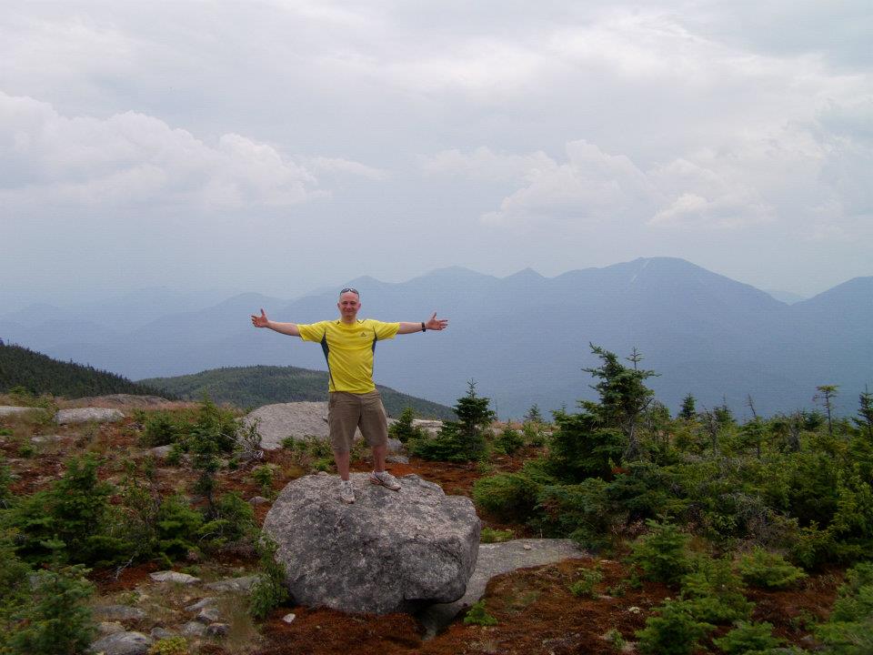
Having no idea how to guage a mile walking through strenuous wilderness, we kept thinking we should be to the summit in no time.  If we could run at 5 MPH for a jog, several miles at a time, walking at 2-3 MPH through the woods should mean we reach the summit in 2-3 hours.  Right?  NO!  We kept climbing, and climbing, and climbing, always assuming the summit would be at the top of the ridge, but all we would find was another ridge and the sounds of growling stomaches.  At this point, the bag of chips and few bottles of water we brought were tilting towards empty.  The hike was also taking it's toll physically.  The group split into stronger hikers and ones that needed more time.  When we thought we had finally made it, we looked up and glimpsed the summit, about another mile away.  It was so frustrating, I couldn't help but laugh and strike pose.  

FYI, a cotton Bob Marley t-shirt and jeans are not the best for hiking.

The last quarter mile of Marcy is an exposed rock scramble that was so exciting to see, the unthinkable happened, some of us ran to the summit.  The thought of being done was so overwhelming that adrenaline took over what calories should have been doing.  With one final push, we had made it.  The experience was so intense that it sparked what we have dubbed "The 46er Quest" for those of us who continued on.  On the summit we came across a benevolent hiker who took pity and passed us a giant bag of peanut M&M's, the ones I'm allergic to.  I let the boys enjoy as I tried not to be knocked out from the celebratory mini bottles of Irish whiskey someone had unexpectedly pulled out.  Jameson is never a good idea on an empty stomach, I don't care how small the bottle is.  A few pics later and we were on our way, not just back to camp, but on our way up 45 more peaks.


Wednesday, March 12, 2014

Esther Mountain

Hike Distance ~ 3.5 miles
Peak: Esther (4,239 ft)

It didn't dawn on me until this post how relatively good the weather has been to our hikes all these years.  Since me and the hiking crew are coming from 4 hours away, we plan our trips weeks in advance with no consideration of the weather.  I can happily say that most of our hikes have been on clear or partly cloudy days.  The sun loves us, the rain seems scared, the snow has only given us one pounding.  The rain Gods must have been angry when we tackled Esther.  Since we had already climbed Whiteface and skipped over Esther, we decided to drive to the top of Whiteface and trek down to the Esther trailhead.  The day was mostly clear, except the one massive cloud that hung over Whiteface.  We drove up the peak while passing bikers out for a casual ride that climbed 3,700 feet at an 8% grade.  We also drove into the thickest fog that we've ever seen in the mountains, before realizing that it was a cloud.  Starting our climb with a descent was a bit weird, but we made it to the trailhead in no time to make the 1.2 mile climb up Esther.  As we turned to head up Esther the rain gave us a blasting the likes of which we've never seen.  We found ourselves trekking up and through ankle deep streams before reaching the summit.  Allie was the only one brave enough to bring her phone to snap the few pics of the day.

      
The plaque beneath our feet commemorates Esther McComb, who at age 15, accidentally climbed the peak on her way to Whiteface.  It is the only High Peak named after a woman; you go girl!

Whiteface Mountain

Peak: Whiteface (4,865 ft.)
Hike Distance: 10.4 miles round trip via Wilmington Trail
Trail Map

Our first ventures into the mountains were always a bit uninformed, at times foolish, but always thrilling.  The common logic says you should climb Whiteface and Esther at the same time.  We made the silly mistake of climbing them separately, despite the fact the trail for Esther is only about a mile trek off the trail to Whiteface.  No mind, it meant having twice as much fun.  This was a special hike because it was the first that Allie joined Brian and I on; she had no idea what she was getting herself into by hanging with us.  Nineteen summits, a world of jokes, mocks, and laughter later, she has been thoroughly integrated into the crew.


The classic route up Whiteface, although there are many, is the Wilmington Trail off of NY 431.  The trail ascends some 3,700 feet, but you barley feel it due to how long and gradual the hike is.  Whiteface is unique in the ADK's for two reasons.  Firstly, it is the only High Peak with a ski resort on it, and it is also the only one with a road that travels up its spine.  The road was opened in 1935 in a ceremony presided over by President Roosevelt, who, as Governor, initiated the project to began with.  Climbing the mountain can be a bit odd in the summer as you stumble upon the seasonally abandoned ski resort and chair lifts.  They make for some great photos for our future album cover if we ever start a band though.

It took about 10 tries to take this pic with a precariously balaned iphone
The day was blistering, but as we got closer to the top the wind help cool it down a bit.  The trail is strewn with debris from storms and slides, but you also pass through some clear-cut spaces that were there to make way for resort.  To be honest, the further up the mountain you get, the more you feel like a mountain dwelling tourist than a hiker.  We didn't let the development get us down, as we came across bizarre purple-winged insects and friendly frogs we got reminded we were still in the mountains.


The last 3/4 of a mile, the trail snakes its way through high brush and stubby trees, allowing for some great views towards the summit and the castle/weather observatory that sits up top.  For anyone who climbs up Whiteface, be prepared for an awkward dynamic upon reaching the summit.  Because of the road, stairway, and elevator that assist the time-crunched or less athletically capable to reach the top, we were among everyone from senior citizens to 8 year olds in flip flops.  It was hard not to have a bit of smugness since we actually climbed our way.  We were overwhelmed by the general jovial feel of the summit though; everyone was just happy to be there looking out over the ADKs, with views all the way Canada.


Tuesday, March 11, 2014

Street and Nye Mountains

Hike distance: 8 miles round trip
Peaks: Nye (3,890 ft.), Street (4,166 ft.)
Trail Map

There's nothing like the first climb of a new year.  This one came much too far into the new year for my taste, but it finally happened so I'm not complaining.  This time around me and the crew took on two mountains without official trails in the waning weeks of winter.  Going off trail is always a bit unnerving, because, admittedly, none of us are that handy with a compass should we go off trail.  Street and Nye are the easiest of the unmarked mountains though, so we figured this would be a good place to start.  The trail head is at the Adirondack lodge and picks up when the trail up Mt. Jo cuts right.  We ducked left and headed into the unknown.  It was supposed to be a frigid day, but it was unusually warm after our bodies adjusted to the initial shock.  The ice on the trail made for some fun slip and sliding early in the hike.


The frozen Indian Pass Brook

The trail was mostly packed snow, making for a relatively easy hike since we got to skip the hopping from boulder to boulder.  The surprise of being so monstrously warm made us all drenched from our own sweat, despite the temperature being in the teens.  We passed over Indian Pass Brook on top of an ice bridge that formed from one side of the riverbank to the other.  It was so calm and serene, which was ironic given the fact that the brook can be impassable during the spring melt.  We made good time up the trail that was conveniently plowed by the snowshoers who came before us.  We even had time for a goofy pose or two.  It's worth mentioning that I accidentally hit Allie in the face with a chair earlier in the day, and neither she, nor Brian, would let me live it down.  I argue it was a soft chair and she was fine after the shock of impact.  As proof:


Brian navigating a steep section
The fork for the two mountains is in a clearing that is marked clearly on a tree bearing the etchings of which way to go.  Nye, famously, is the second shortest of the "High Peaks".  Inaccurate measurements placed the peak at 4,000 feet, when it doesn't even break the 3,900 foot mark.  It remains on the list of High Peaks for old times sake, but it is a wooded summit with practically no views.  We choose Nye first to get it out of the way.  It is very close to the fork and took no time to get to.


Street was our final destination for the day, our 25th mountain, and had much better views than its sister peak.  After the customary summit dance and gnawing on frozen jerky and protein bars, we took in the best sights of the day.


Thursday, March 6, 2014

Cascade and Porter

Peaks: Cascade and Porter
Distance: 4.7
Trail Map

Hiking in the winter adds an entirely different dynamic to climbing, particularly if there is a lot of snow and wind.  This was our second hike in winter conditions, but the previous one up Phelps was early enough in the season that it didn't get truly wintery until the last half mile.  We wouldn't be so lucky this time.  Just driving to the trailhead involved a 5 hour cruise through near whiteout conditions.  Brian and I we're considerate enough to fall asleep in the car and allow Allie to drive through the blizzard in solitude (insert sarcasm, she wasn't happy).  After a brave drive it was time for a brave hike.  Barley able to see the cars headed down the road, we jumped onto the trail and made haste.

Blizzard pose

Cascade and Porter are considered the easiest climbs in the ADKs.  The trail is one of the shortest and the views are very rewarding considering Cascade is almost completely bald.  What you don't hear is how the trail gains thousands of feet in altitude in that very short hike.  It was by no means hard, but the gail force winds that day made for frigid hiking at the exposed sections.  Without snowshoes or microspikes even, we made it to the outskirts of Cascade's summit in quick time.  Feeling good about ourselves, we dropped our packs where the snowpack ended and made our way to the rocks to take in our first winter view.  The wind had other ideas.


The portal to Cascade's summit
The day had partial visibility, making for a sublime panorama.  The winds at this point were gusting well over 80 mph.  You could lean back as if in an armchair and have the wind hold your weight for a few seconds.  The virtual skating rink that encased the rocks made for a pretty easy form of transport, just put out your arms and let the wind slide you across.  It was a thrilling experience, even though we all got pinned to the side of the mountain on several occasions, unable to move or even look up.  As we turned to leave after snapping a few shots, a gust came down so ferociously that every hiker on the summit simultaneously ducked so they would not be blown over.  It was some of the most fun I've had climbing before, but it was brutal, painfully so.

Allie holding pinned by a hurricane gust

The rare NY Grizzly Bear atop Porter
The climb over to and up Porter was quick, but chilly after the ice blasting we got on Cascade.  We celebrated our second peak of the day, took a few more shots, huddled for warmth and then got the hell out of there.  Despite the periodic pain from the cold, this was one of my favorite climbs.  I also learned a great remedy for the cold in our post-climb downtime: hot cider and carmel vodka.  In the words of Sylvia Plath, “I began to think vodka was my drink at last. It didn’t taste like anything, but it went straight down into my stomach like a sword swallowers’ sword and made me feel powerful and godlike."

Giant Mountain and Rocky Peak Ridge

Peaks: Giant Mountain and Rocky Peak Ridge
Distance: ~11 Miles
Trail Map


If you've read my hiking stories long enough, you've probably been introduced to my Bears, Allie and Brian, but you might not have met my Gator.  One of my best friends/practically family is named Patrick, but through a series of comedic events he has been dubbed Gator Boy, or GB for short.  GB is the consummate outdoors man, with big dreams of attending the NOLS wilderness education school and landing a job in the outdoors.  These days he lives in Indiana so I only get to see him back out East so often.  One summer visit he wanted to take on some high peaks, thus begins our climbs of Giant and RPR.

The Friendly Campground Cat

We drove up to the High Peaks region the evening before, after a full afternoon of boozing on another friend's boat.  Brian was wheel-man while the crew tried to sober up on the ride.  Needless to say, we slept well.  A fourth friend, Julian, also accompanied us on the trip.  The last time I saw Julian he was skinny and got winded a bit easy.  About three years and 10 lbs. of muscle later, Julian could literally run up the mountain if he wanted.  The hike is short enough that we were able to take our time getting up and play with the fluffy gray cat that patrolled the campgrounds.  We made our way down route 73 where an oddly enormous sign marked the parking lot and trail head from the road.


The ascent was unusually easy for a good many miles.  It was a surprise given the stature of the mountains.  Giant earns its name due to its relative isolation from other peaks combined with its enormous width and considerable height.  The peak looms over the town of Keene Valley below, making an ominous shadow at the right time of day.  We moved through the woods at a considerable pace until the worst happend, I uttered the words "This is a joke!"  Almost immediatley thereafter, as if on cue, the gentle and gradual ascent of the trail gave way to endless rock scrambles; "Hello foot.  Meet mouth!"  I wasn't upset, I love to scramble, but God was it a hot and sticky day.  It was the type of day where your vision was blurred by the sweat rolling down your face and into your eyes.  The trail levels out and you have the option to cut right and head to RPR, or cut left, up a rock wall, and bag Giant.  It was about a mile either way.  We opted for Giant, not realizing we could even hike two peaks in one day; we hadn't quite got the whole peak bagging thing down.

GB
Right before the split we met a girl in her mid-20's, covered in dirt, with a yellow bandanna who could unleash more words per minute than any human being possibly should or be able to.  After a barrage of needless anecdotes, she informed us she was going to bag both mountains, that it was the sensible thing to do, and even implied in her tone that we were fools or lazy for not considering it.  We bid her adieu by silently kicking the air a few feet from her behind as she turned to climb Rocky.  The summit of Giant was crowded, as is expected in the summer due to the easy accessibility of the trail head to the road.  The four of us could have stayed there all day, chatting with veteran 46ers who were up there for their 3rd or 4th time.  There was also a group of hikers from Canada who were apart of a club that seeks to hike every mountain above 4,000 feet in the Northeast, all 111 of them!  The crystal day was turning a bit grim in the distance, but we figured we were looking far away given our altitude.  After a little coaxing I talked the crew into taking on RPR too.  Not too long after leaving the summit we came across our ripe smelling friend who offered the advice to hike Giant and RPR in tandem in the first place.  Apparently she got to the bottom of the col between the mountain and realized she was too tired to take them both, so she made her way back up to Giant.  I felt bad, but the irony was too much not to let out an internal chuckle.  


We set off for RPR, which was separated from Giant by a col that dipped before abruptly climbing again.  We got there in no time and made a few more friends while taking in the view.  We may have been building as hikers, but definitely not meteorologists.  The sky was outright black now, pounding the mountains in the distance with torrents of rain we could only imagine.  None of us minded getting wet, but no one had a change of clothes, nor did we want to sit for four hours in a car soaked.  We hustled back down the col, but as we started ascending Giant again, we had to stop so Brian could nurse a pretty bad cramp.  I have no idea how we made it back before the rain, but all hell broke loose a few moments after hitting the car.

Julian feeling like Superman on RPR.
The scared Giant from RPR
RPR from Giant. Look close and see the hikers on top.
This is one of the "easier" climbs in the ADKs with one of the greatest rewards.  The views from Giant are breathtaking, and well worth the sweat and colorful strangers.